
NOAA Aerial Imaging Helps Hurricane Ida Recovery

By Abby Proch, former editor

The saying goes that a picture is worth a thousand words. For people in areas hard hit by Hurricane Ida, the aerial images taken by the NOAA National Geodetic Survey Remote Sensing Division yield just one: Thanks.
“The greatest fear of anybody: I just want to know if my home’s there or not. Whether they know it’s a good or bad outcome, at least they know,” said Michael Aslaksen, NGS National Chief of the Remote Sensing Division.
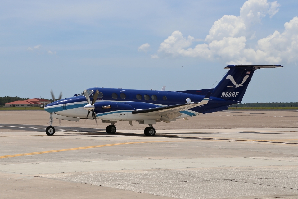
Days after the Category 4 hurricane barreled through coastal Louisiana and Mississippi — 16 years to the day after the historically debilitating Hurricane Katrina struck — the NGS’s Beechcraft King Air 350ER “NOAA 68” took to the skies to assess the storm’s damage.
What it found — blocked roadways, toppled trees, damaged homes and downed powerlines — is now reflected in georeferenced aerial images being used by countless agencies to dole out resources and give many evacuated residents peace of mind.
Getting The Picture
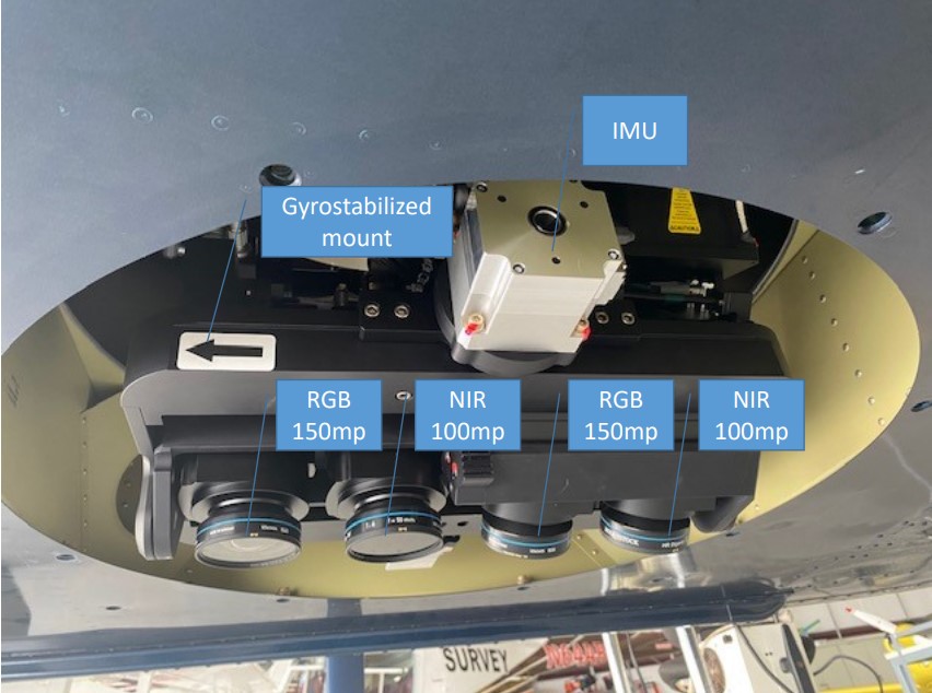
NOAA 68 took flight the morning of Aug. 30, 2021, with a survey-grade, medium format digital camera system, version 6 of the Trimble/Applanix Digital Sensor System. The twin-engine turboprop made pass after pass, recording vital imagery with its two RGB 150-megapixel cameras, covering a combined 120-plus-degree field of view, says Aslaksen.
Direct georeferencing hardware and software provided by Applanix helped link each pixel of every image to its corresponding GPS coordinates. On the ground, the georeferenced images are stitched together to form one contiguous image layered atop an interactive map, powered by Leaflet and OpenStreetMap. Applanix also provided image calibration support, and Lead'Air integrated the components and manufactured the camera, processing hardware and camera controllers.
NOAA 68 has been flying at an altitude of about 1,200 feet for much of the mission. That’s a little lower than Aslaksen would normally like to see, but cloud cover has been a factor. The sweet spot is about 5,000 feet, where cameras can capture a six-inch resolution, he said.
This mission was just the second fielding for the newly installed camera system, which Aslaksen says debuted earlier this summer to survey damage left by Hurricane Henri in Rhode Island. After leaving New England, the plane traveled to Austin where it approached Hurricane Ida from the west.
A week in, images covering hundreds of miles are now visible to all — FEMA, Army Corps of Engineers, Coast Guard, Red Cross, utility companies, state and other federal agencies, and the public.

Countless Images, Countless Applications
In 2018, a woman who fled Hurricane Michael relied on aerial imagery to check on family who did not evacuate. Aslaksen said the woman saw her family had written “HELP” with debris in their yard, and so she rallied to get them help.
This anecdote illustrates the practically incalculable benefits of aerial imagery, illustrating just how NGS’ aerial imagery helps individuals all the way up to national agencies identify urgent needs, such as preserving life and property, and determine how to reach those locations quickly and safely.
For example, FEMA overlays pre-event maps (e.g., those used for tax purposes) with emergency event-related imagery such as NGS’ to determine the extent of damage. FEMA can rely on that aerial imagery to approve housing, funding and other support services to families and individuals, rather than validating those needs through labor-intensive foot patrols, said Aslaksen.
For this event, public utilities in Louisiana are using the images to assesses damage to utilities, dispatch proper crews and determine the best access points. Meanwhile, the Louisiana National Guard relies on them for search and rescue operations, said Aslaksen.
Another early report to Aslaksen’s office indicated a possible oil spill in the Gulf of Mexico. An image shows what appears to be a miles-long oil slick near an offshore rig with “Enterprise Offshore Drilling” displayed on its helipad. The Associated Press reported the brownish-black slick just south of Port Fourchon, La., and later confirmed an oil spill in that area. According to the AP, a contractor for Talo Energy has placed a containment dome at the site to stop the leak but said it does not own the burst pipeline. The owner of the pipeline has not yet been identified, said the AP on Sept. 8.
Use applications for the spatial data are broad and varied. Aslaksen pointed to a more unusual application: When tornadoes ravaged southeastern Alabama in 2019, the forestry department relied on aerial imagery to estimate timber loss and to forecast lumber prices.
Setting Sights On Faster Processing
While there is plenty to praise about aerial imagery’s widespread applications, there remain challenges to its execution. Finding fuel and securing air space are both concerns after emergency events. Power outages at airports can shut down pumps, causing planes to land or reroute to an operable airport. And, air space can become crowded, though Aslaksen says temporary flight restrictions keep non-essential aircraft from flying.
But what’s really holding NGS back — and will ultimately move them forward — is achieving high-speed internet access onboard the NOAA 68.
“Positioning of aircraft and imagery in real-time; processing into JPEGs in the plane in real-time. The next logical step would be for us to directly transmit the imagery that we process in the airplane now to the cloud so we can mosaic it as we continue to collect,” said Aslaksen.
Right now, the process is as follows: Crews deplane in Mobile, Ala., to hand off a hard drive of data to a team member on the ground, who then uploads the data to a cloud platform. Once data has been uploaded, it takes the team another 4-6 hours to stitch those georeferenced JPEG images into a near-seamless, interactive map.
The process seems clunky, but it is an improvement. In 2003, before NGS introduced NOAA 68, they could not georeference aerial images. What’s more, it took 24 hours to deliver such images. At the time, the NGS considered it an improvement, spurred by the toilsome recovery phase following the 9/11 attacks. In 2001, NGS Remote Sensing Division personnel used film cameras to record images of the destruction at the Twin Towers. It took five days to process those images, said Aslaksen.
Looking ahead, Aslaksen only sees the capabilities improving. Specifically, he’s looking at radar imagery to supplement aerial imagery, especially when flooding and storm surge are probable or occurring. Radar’s unique capabilities allow it to receive data through cloud cover and provide improved feedback on topography. While the NGS can access commercial satellite data for mapping, having the capability on an aircraft would provide independence and flexibility when time is precious.