
Airborne Mapping Spectroscopy At NASA's Jet Propulsion Laboratory

By Anatoly Vasiliev
A recent meeting of the Optical Society of Southern California (OSSC) held in Pasadena, Calif., featured a terrestrial tour of airborne mapping spectroscopy at Nasa’s Jet Propulsion Laboratory (JPL). Mark Helmlinger, Earth Scientist of JPL's Earth Sciences team reviewed the Airborne Visible / Infrared Imaging Spectrometer (AVIRIS) program and demonstrated a LEGO Model of the Multi-angle Imaging SpectroRadiometer (MISR).
AVIRIS is a proven instrument in the realm of Earth Remote Sensing. It is a unique optical sensor that delivers calibrated images of the upwelling spectral radiance in 224 contiguous spectral channels (bands), with wavelengths from 400 to 2500 nm. AVIRIS has been flown on four aircraft platforms: NASA's ER-2 jet, Twin Otter International's turboprop, Scaled Composites' Proteus, and NASA's WB-57. The ER-2 flies at approximately 20 km above sea level, at about 730 km/hr. The Twin Otter aircraft flies at 4 km above ground level at 130 km/hr. AVIRIS has flown over North America, Europe, portions of South America, and Argentina. This shows AVIRIS' adaptability to different altitudes. The future of Earth science measurements requires that aircraft and spacecraft have even greater capabilities, packaged in more compact and lower-cost aircraft or spacecraft.
AVIRIS generates “imaging spectrometer data” through a process of “imaging spectroscopy,” terminology AVIRIS scientists are working to popularize in lieu of the more commonly used term "hyperspectral." This transition will allow them to communicate more clearly with their physics, chemistry, and biology science colleagues.
The AVIRIS program has been producing and operating instruments for decades. AVIRIS Classic, and now AVIRIS Next-Generation, continue to fly terrestrial targets for various NASA-funded principal investigators (PIs). At OSSC, Helminger’s inside tour elaborated on the program through stories, pictures, videos, and optical demonstrations of applied mapping spectrometry — from the ground up to other planets and moons.
“We don’t believe in global warming. We measure it,” said Helmlinger in discussing AVIRIS. In fact, the main objective of the AVIRIS project is to identify, measure, and monitor constituents of the Earth's surface and atmosphere, based on molecular absorption and particle scattering signatures. Research with AVIRIS data is predominantly focused on understanding processes related to the global environment and climate change. Recently, AVIRIS’ space-based remote imaging spectroscopy research focused on the Aliso Canyon methane leak.
Between October 2015 and February 2016, the Aliso Canyon gas storage facility near Porter Ranch, Calif., let slip a massive, accidental methane release. The Hyperion imaging spectrometer, operated under AVRIS on board the EO-1 satellite, successfully detected this event, achieving the first orbital attribution of CH4 to a single anthropogenic superemitter. The findings recently were published in the journal Geophysical Research Letters by NASA’s David Thompson, along with a team of colleagues from JSL, Caltech, the Hemholtz Centre Potsdam (Germany), and NASA’s Goddard Space Flight Center.
The Hyperion spectrometer is an optical instrument that scans in many hundreds of wavelengths, which allows for the identification of specific gases. In effect, Hyperion measured shortwave infrared signatures of CH4 near 2.3 µm at 0.01 µm spectral resolution and 30 m spatial resolution. The spectral data processing algorithms used by AVIRIS examine the imagery from the spacecraft to identify the unique spectral signature of methane, and then map it over wide locations. As a result, Hyperion detected the plume on three overpasses, despite very poor illumination (<25° solar elevation), mapping its magnitude and morphology. JPL released the image below to accompany the research.
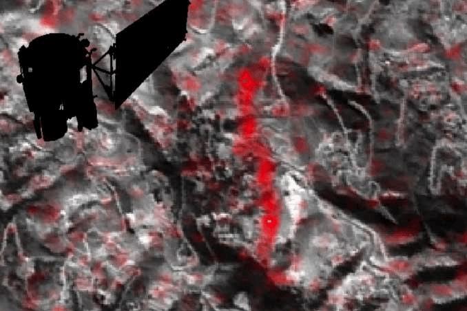
These orbital observations were consistent with measurements by airborne instruments, even though the spacecraft that carries Hyperion currently is drifting in its orbit (having long since run out of fuel), and despite the fact that the spectrometer was not designed to measure methane. The orbital observations marked the first time a satellite-based instrument was able to identify and isolate a single-source emission of methane from space. Future, more strategically tailored methane measurements could be considerably more accurate.
The AVIRIS research has emphasized the importance of environmental monitoring using space-borne (e.g., satellite-based) platforms. This technique is especially important when applied to the early detection and localization of such events as the Aliso Canyon methane leak, which is estimated to have dumped 109,000 metric tons of methane into the atmosphere in less than five months. Another study, which estimated the event’s CH4 pollution at 97,100 metric tons, equated the leak’s impact to the yearly greenhouse gas emissions from 572,000 cars.
The AVIRIS work comes at a time when remote imaging technologies, more and more, are helping scientists understand the global distribution and major sources of air pollution. Recently, another satellite-based study identified dozens of new, major sources of sulfur pollution around the globe. Improving greenhouse gas leak observations, as part of monitoring various sources of air pollution, will not only allow more precise estimates of how much individual countries are contributing to the atmospheric greenhouse gas burden (a key goal of the Paris climate agreement), it will help track the hardest-hitting gases in particular, such as methane.
While methane has a far shorter atmospheric lifetime than carbon dioxide, it causes far more warming than an equivalent amount of CO2 while it lasts, making large releases like the Aliso Canyon methane leak particularly consequential. The space-based gas-spotting trend will only burgeon, driven by new research and further improvements to its enabling technologies.
About The Author
 Dr. Anatoly Vasiliev’s main areas of research are fiber optics (FO) communications, spatial light modulators (SLMs), adaptive optics, phase conjugation, optical processing, and pattern recognition. He was Senior System Architect at KLA-Tencor and the Adaptive Optics System Physicist and Laser Physicist for High Energy Lasers and Advanced Beam Control Programs at Raytheon. At Physical Optics Corporation, Dr. Vasiliev has successfully developed target tracking and synthetic aperture radar automatic target recognition (SAR ATR) algorithms and designed optical joint transform correlators for SAR ATR, eye-tracking, authentication, and security applications. He has also been involved in several commercial design projects on FO communications, backlights for LC displays and automotive lighting.
Education: Ph.D. in Radiophysics, Academy of Sciences, Moscow; MSEE, State Institute of Electronics and Mathematics (former Institute of Electronics Engineering), Moscow
Patents & Publications: Dr. Vasiliev has authored more than 150 publications, including 40 in refereed journals, and holds 19 USSR and 5 US patents on liquid crystal devices and optical processors and system design.
Awards: State Prize of the USSR in Science and Technology in 1985. Raytheon Excellence in Technology Business and Enterprise Awards (2008). Senior Member of Optical Society of America (2010). Senior Member of SPIE (2015)