Computers Show New Strategies To Avoid Satellite Collisions

Orbiting satellites collect and relay vast amounts of data critically needed for civil, commercial, scientific, and national security applications. The USA and many other countries depend on space-based systems to navigate, communicate, monitor environmental changes, and provide surveillance data. Lawrence Livermore National Laboratory (LLNL), Los Alamos National Laboratory, Sandia National Laboratories, and the Air Force Research Laboratory are collaborating to improve capabilities for detecting and monitoring space debris and other threats to space operations. Since 2008, a team of computational physics and engineering experts at LLNL has been designing a comprehensive set of analysis, modeling, simulation, and visualization tools called the Testbed Environment for Space Situational Awareness (TESSA).
TESSA improves performance analysis of the collection of radio-frequency and optical-sensing systems called the Space Surveillance Network (SSN) currently used by the US Air Force Space Command to monitor space activities. TESSA can also assess the relative efficacy of new sensor configurations and operational methods. It uses high-performance computing, optical and radio-frequency phenomenology and instrumentation, the physics of hypervelocity impacts, and data mining (a statistical process that quickly sifts through mountains of information to locate important nuggets).
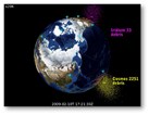
The urgency of our team's work on TESSA was underscored by the February 10, 2009 collision between the defunct Russian satellite, Cosmos 2251, and the operational communications satellite, Iridium 33. Working closely with US Air Force Space Command, our team performed detailed, high-performance computer simulations of the expected debris distribution from the collision (see Figure 1), then computed the increased risk to other satellites to determine whether this danger was high enough to justify repositioning specific equipment. The conclusion was that the collision risk for more than 100 active satellites was increased by about 50%, but that was not enough to warrant disrupting operations to reposition any specific systems. However, it did highlight a worrying trend, which is with every collision, the resulting debris increases the risk of future collisions. TESSA was used to analyze the Cosmos-Iridium collision.
Although the crash exemplified the growing hazard to space operations caused by the increasing amount of orbital debris, future collisions between maneuverable satellites and debris might be avoided if actionable information were provided to satellite operators in advance of close encounters. The Joint Space Operations Center now routinely performs conjunction analyses to predict how close objects in the space catalog will approach active satellites. Although these predictions use the best information available from the SSN, uncertainties in the orbital position knowledge of many space objects make it difficult to determine whether the collision likelihood is high enough to justify repositioning the satellite.
Our team recently described a new method using intelligent tasking of auxiliary sensors to produce information that can be acted on to avoid collisions.3 A network of sensors can obtain more precise orbital information for objects that exceed a collision risk threshold. This information can be used to prevent a collision between a specific set of satellites during a specified time interval. The tasking of this network is cued by the conjunction analysis results using SSN information. Our team used TESSA to assess the improved analysis quality that was achievable with a distributed network of small, optical imaging sensors.
The result was that a moderate number (~10) of small (~1m aperture) optical-imaging sensors was sufficient to make an accurate (~100m uncertainty) and timely (within ~1 day) determination of whether any two orbiting objects that were expected to pass closely (based on SSN information) were actually at high risk of colliding. This data could be used to justify repositioning a maneuverable satellite. The remaining question is how the number of sensors needed to make this determination will increase for multiple pairs of orbiting objects. Approximately 20,000 objects are currently being tracked by the SSN, and there can be up to 100 close conjunctions predicted with maneuverable satellites each day. So, an auxiliary sensor network designed to address these conjunctions will have to be sized to handle this rate. However, this may not result in a significant increase in the number of sensors if the necessary observations can be scheduled at different times. Nevertheless, this remains an open question and will be the subject of future work.
SOURCE: SPIE
